Choosing a land survey company is an important step in understanding the size and limitations of a commercial property. An experienced land survey company will provide the foundational services needed to analyze a property, ensure its legality, and outline provisions for future development.
National Due Diligence Services (NDDS) is one of the fastest-growing commercial due diligence firms in the nation, offering a selection of touchstone services with a focus on timeliness, communication, and next-level design.
The real estate industry is rapidly growing, with $809 billion in commercial property sales in 2021. Discover the three land survey company services that allow insight into strategic next steps for a commercial real estate transaction.
ALTA/NSPS Survey
An ALTA/NSPS Survey adheres to a set of national standards established by the American Land Title Association (ALTA) and the National Society of Professional Surveyors (NSPS). As the most extensive land title survey available, an ALTA Survey is a core component of a real estate due diligence package, and its completion can be a protocol for the buying or selling of commercial real estate.
In some cases, an ALTA Survey can be a prerequisite for funding for commercial development and acquisitions. It can also provide a technology update for the boundaries of vacant land and enable backing for property disputes.
Because an ALTA Survey is usually required before title insurance can be issued on a commercial property, a land survey company will follow a sequential process to ensure the plat map is quickly approved by all involved parties.
An ALTA/NSPS land title survey relies upon a current title commitment for the recorded legal description and any exceptions from Schedule B of title. During the fieldwork portion of an ALTA survey, the surveyor will not only utilize the information from the title commitment, but also include any identifying encroachments, easements, above-ground utility connection points, log any unrecorded information, and more.
Zip Map
A Zip Map was first offered by NDDS in 2009 as a tool for uncovering title-related issues through aerial photography. While a Zip Map is not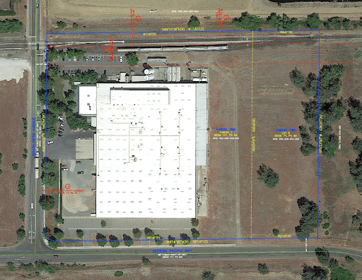 a boundary survey, it can provide a general property assessment before the purchase of an ALTA Survey and determine whether or not the property has any title and survey-related issues.
A Zip Map is ideal for dams, wind and solar projects, industrial facilities, and vacant land, as it captures a large expanse and can easily access areas where safety or environmental conditions may be a concern.
On a Zip Map, an aerial photograph from Google Earth Pro or a currently flown image and will feature an overlay of the drafted legal description, Schedule B items & flood zone information. Each Zip Map is delivered utilizing our color-coded format for ease of review. Once completed, the resulting Zip Map can be distributed to applicable parties and, if needed, rolled into a combined price of an ALTA survey.
Once an acceptable image has been secured, the NDDS team will conduct an in-depth examination, plot the property, and reference all easements, recorded maps, and flood zone information. When a property has been fully recorded, the resulting Zip Map can be distributed to applicable parties and, if needed, rolled into a combined price with an ALTA Survey.
Land Development and Design Surveys
The land surveying market is set to reach $9.45 billion by 2026, making it an important focus for our company. Aside from the well-known ALTA Survey, American Surveying & Mapping, Inc. (ASM) also offers Florida developers a selection of key commercial land development services that ensure alterations are safe and in the best interest of a property.
With our innovative technology, ASM is able to provide cost-effective, precise, and timely results with established safety protocols for all on-site parties. ASM development and design services cover every angle of the commercial process.
- Platting
- Route Surveys
- Encroachment Resolution
- Topographic Surveys
- Flood Determination
- LOMA Applications
- Wetland Surveys
- Boundary Surveys
- Title Reviews
- And more
Browse Our Services
NDDS employs land surveying crews across the nation who are available for any commercial property needs. Visit our website to learn more about our services and request a quote or speak directly with a member of the NDDS team.


