Unmanned Aerial Vehicles – Drones
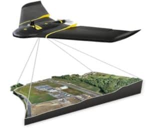 Our in-house Research & Development professionals continually strive to create and stay on top of the most current, innovative and productive technologies. We have invested heavily in Unmanned Aerial Vehicles (UAV) or Drones creating a safer and more efficient means of gathering data for our clients. With survey-grade accuracy, we are able to gather millions of data points in one short flight, allowing us to produce the most accurate and photorealistic orthomosaic and detailed mapping possible.
CAD Technology

Our in-house team of Licensed Surveyors and CAD professionals are always taking great strides to stay on the cutting edge of technology. Our team developed the industry’s first Interactive Survey to streamline the review process with the latest technology and standardized format to meet the needs of our clients.
Surveying Technology
Our survey operation teams use the latest GPS surveying technology the industry has to offer. This includes static observation for precise control and baseline positioning, rapid static for routine second and third order control points, and RTK for precise real-time (on the fly) horizontal and vertical data for hydrographic and topographic surveys. Additionally, Geographic Information System (GIS) maps are created for a wide array of purposes including master planning, operations and maintenance, zoning and tax assessment, and emergency response.